One or more of these maps show the result of aggressive colonial expansion. Which one? (#Poll in the next message.)
2 media
One or more of these maps show the result of aggressive colonial expansion. Which one? (#Poll in the next message.)
@flancian
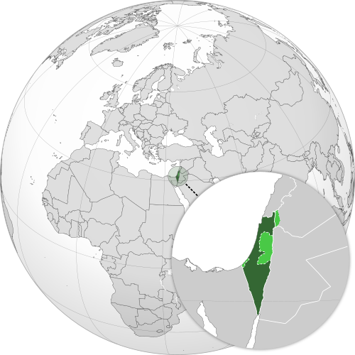
Things would be a lot better if the second map actually represented reality.
@notsoloud I thought it did, thanks! What's missing from the map? Looking
@flancian
Israeli settlements in the West Bank. Israeli controlled areas of Gaza. Areas of Gaza where Palestinians are not allowed. And all the roads and walls and check points in the West Bank. You should probably ask people driving in the area (on the Palestinian side) about this, but I doubt it's de facto a contiguous territory like on the map.
@flancian This image displays a grayscale world globe centered on the Eastern Hemisphere, with a circular inset map in the lower right corner. A dashed line links a small locator circle on the main globe to the inset, indicating the specific region being highlighted. The inset map focuses on the Levant, showing the Mediterranean Sea to the west and parts of surrounding countries like Egypt, Jordan, and Syria in light gray. Inside the inset, the landmass is colored to distinguish Israel in dark green from the West Bank and Golan Heights, which are shaded in light green. The main map features a visible grid of latitude and longitude lines over the continents of Europe, Africa, and Asia.
―
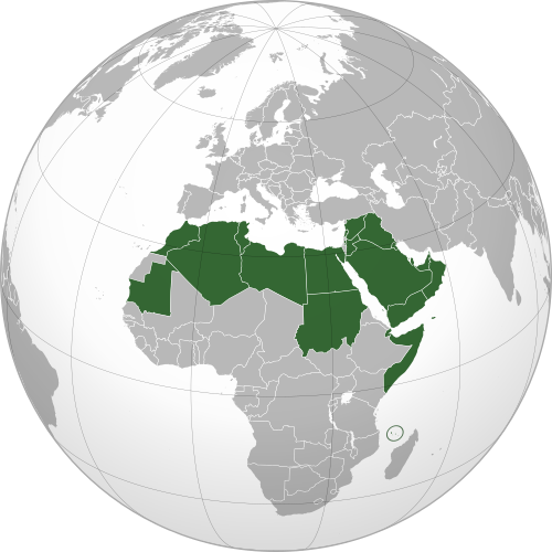
This image displays a 3D rendering of a globe centered on the African continent. Most of the landmass is depicted in light gray, while a large region in the north and east is highlighted in dark green. This green area encompasses North African countries such as Morocco, Algeria, and Egypt, along with the entire Arabian Peninsula and the Horn of Africa. The highlighted region extends into the Middle East, covering nations like Saudi Arabia, Iraq, and Iran. Additionally, a small, isolated green circle marks a location in the Indian Ocean off the eastern coast of Africa.
Provided by @altbot, generated privately and locally using Qwen3.5:9b
🌱 Energy used: 20.211 Wh